
Without understanding our place in a system, we don’t know how to adapt most effectively when part of that system changes.
As climate change continues to impact the Pacific, the local structures and ecosystems of communities are being affected. Changes flow throughout the system, from households to hills and forests to oceans, and cannot be responded to as isolated issues.
Understanding the interconnectivity of these different elements is essential. To help with this, Live & Learn’s CRI teams are visiting communities and working with them to understand their local structures and systems, especially ecosystems. Part of this means helping the village better understand and conceptualise how they interact with and are part of these systems.
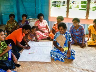
One of the CRI women’s groups working on their village map
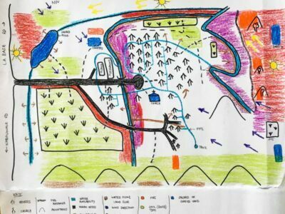
To do this, community members draw maps of their villages and the surrounding areas to show the systems working within the community and how the people connect with them. Borrowing from the field of permaculture, which emphasises the interconnectedness of human and non-human systems, they include as many elements as possible of their local ecosystems, to show how they interact with them.
These elements include types of soil and vegetation, the flow of air and water, animal species and their habitats, and, importantly, the place of people within them. Documenting the knowledge that already exists in the community about these elements provides a basis for introducing nature-based solutions that are more holistic and effective.
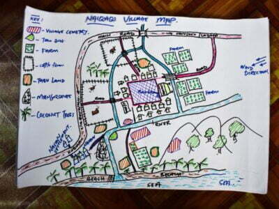
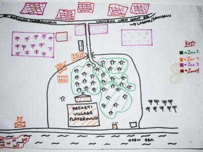
Community members produced multiple maps. These are not only useful and practical documents which show the deep understanding community members have of their land; they also turn out to be wonderful works of art. The communities end up with colourful maps full of detail and life, showing zones from vegetable gardens to kava and coconut plantations and where the village sits alongside the forest, ocean and other ecosystems.
Mapping these elements out in the way the communities are doing contributes to and clarifies the knowledge they have about their local systems and the impacts climate change, land clearing, pollution and other pressures are having on them. In turn, these maps will provide guidance for the Climate Resilient Islands journey ahead.
Climate Resilient Islands is a New Zealand Ministry of Foreign Affairs and Trade initiative, implemented by Live & Learn Environmental Education, with funding provided by the New Zealand Government.
